Table of Contents
ToggleNavigating land use and property regulations in California can be overwhelming without the right tools. For those living, working, or investing in the Central Valley, the San Joaquin County zoning map is an essential resource. It provides comprehensive zoning information, helping residents and developers understand land-use rules, permitted activities, and legal boundaries across the county.
Whether you’re planning a home renovation, looking into agricultural zoning, or evaluating a commercial investment, using the San Joaquin County zoning map ensures that your property decisions align with current zoning regulations. With tools like GIS viewers, parcel lookup options, and zoning code explanations, it’s now easier than ever to access reliable and up-to-date information online.
Interactive GIS and How to Access the San Joaquin County Zoning Map
The interactive GIS portal available at sjmap.org offers users a modern and user-friendly interface to explore zoning across the county. This online San Joaquin County zoning map tool allows you to search for a property by address, assess its zoning designation, and view nearby zoning classifications with a few simple clicks.
GIS features include layers for flood zones, school districts, land use types, and even voting districts, making it a comprehensive planning tool. Users can zoom in on specific parcels or zoom out for a broader district overview. These interactive elements empower homeowners, real estate professionals, and developers to make informed land use decisions with confidence.
Decoding Zoning Codes in San Joaquin County
Zoning codes determine how a specific piece of land can be used. The San Joaquin County zoning map uses a variety of codes such as AG-40 for agricultural use, AU-20 for agricultural-urban fringe, and R-1 for single-family residential. Each code comes with its own restrictions, guidelines, and potential for development.
Understanding these codes is crucial. For example, land under AG-40 zoning may restrict the type of structures you can build or prohibit subdividing the land. Meanwhile, R-3 zoning may allow for multi-family housing. The zoning map provides not just the code itself, but access to the county’s zoning ordinances so you can fully understand what each designation means.
Parcel Lookup and Property Information Integration
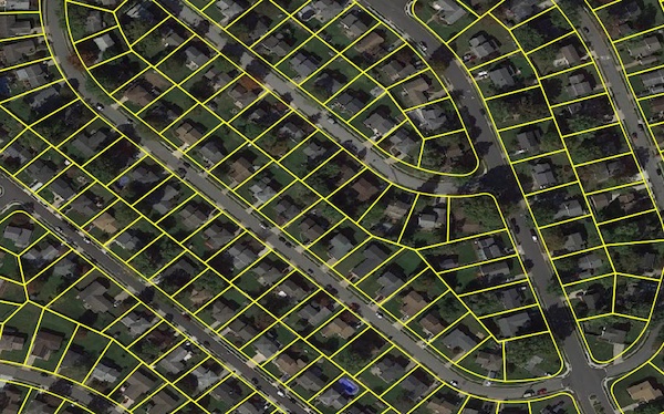
If you’re researching a specific property, the San Joaquin County zoning map integrates with parcel lookup systems to deliver a wide range of data. Parcel maps allow you to identify boundaries, ownership, tax information, and previous assessments linked to that land. This can be vital when planning a purchase, dispute resolution, or development project.
The Assessor’s parcel maps are available through the county’s GIS interface and can be downloaded or printed. This feature connects seamlessly with other systems, such as San Joaquin County property tax records and building permit databases, creating a one-stop-shop for land information.
Planning, Development, and Community Resources
The zoning map also ties into broader development processes managed by the Community Development Department. If you’re applying for permits or planning a subdivision, the San Joaquin County zoning map helps ensure your plans comply with current land use policies. Misinterpreting zoning can result in delays or even legal challenges, so it’s critical to verify your parcel’s status before starting construction.
The Community Development Department also provides support for zoning changes, variances, and conditional use permits. Developers, architects, and legal advisors regularly consult the zoning map to support zoning applications or defend against violations.
Why the San Joaquin County Zoning Map Matters in 2025
With ongoing urban development, agricultural shifts, and climate-related zoning considerations, understanding the San Joaquin County zoning map is more important than ever. Whether you live in Stockton, Lathrop, or an unincorporated area, knowing your zoning rights helps you make smarter land decisions and stay within legal boundaries.
The map is regularly updated to reflect changes in policy, district lines, and local infrastructure. As 2025 progresses, having quick access to accurate zoning data ensures residents are not caught off guard by county revisions or new land ordinances.
Frequently Asked Questions
How can I access the San Joaquin County zoning map?
You can visit sjmap.org to use the interactive GIS tools and explore parcel and zoning data online.
What do codes like AG-40 and AU-20 mean?
These are zoning codes indicating land use. AG-40 is for agricultural land with 40-acre minimums, while AU-20 allows a mix of urban and agricultural uses.
Is zoning related to San Joaquin County jail or court records?
No, but zoning issues may sometimes end up in San Joaquin County superior court, especially in land use disputes.
Where can I find information on who’s in custody or jail bookings?
That information is available through the San Joaquin County jail and sheriff department, not the zoning map system.
Can zoning affect property taxes?
Yes, zoning can influence land value, which in turn affects your San Joaquin County property tax assessment.
You may also read: What is a Self Blunting Needle and How Does It Work?


